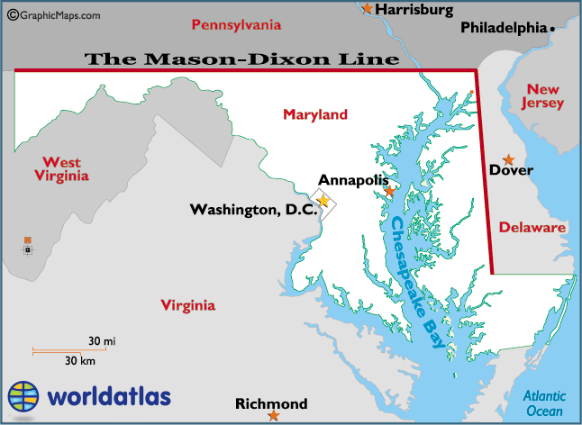
I bet you've heard of the Mason-Dixon Line, but I bet you don't completely know what it is. Today, people think of the famous line as the border between the North and South, dating back to the days of the Civil War. However, the line actually dates back almost a century before the Civil War, and what caused the line to be made dates to a century before that.
The story of the line goes all the way back to the early 1600's. First there was the colony of Maryland. The original charter stated that the northern border of Maryland was at the 40th Parallel. However, when the king granted a charter to William Penn and his colony of Pennsylvania, the problem arose when neither Pennsylvania or Maryland could agree. Maryland thought their northern border was high enough to include the growing Philadelphia, and Pennsylvania thought their southern border was much more south than Philadelphia. A treaty was signed in 1682, which defined the borders for Maryland and Pennsylvania. This might have ended the controversy, but some land that was originally part of Maryland's charter went to William Penn. This land soon became the Delaware colony.
 |
| Mason-Dixon Line |
Another treaty was signed in 1732 between Penn's sons and Charles Calvert (Maryland's provisional governor) which defined the border. Calvert soon chose not to follow the 1732 treaty, claiming that he didn't agree to things in the treaty. Violence broke out between people claiming to be part of Maryland vs Pennsylvania. The crown finally intervened and in 1760 forced Maryland to accept the 1732 borders. This border was defined as 15 miles south of the southernmost house in Philadelphia.
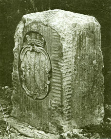 |
| Mason-Dixon Crownstone |
As part of the agreement, the Penns of Pennsylvania and the Calverts of Maryland commissioned a pair of English surveyors to officially map out the exact borders of Pennsylvania, Maryland, and Delaware. Who were these two men? Charles Mason and Jeremiah Dixon. They began work in 1763, and began surveying in 1765. They completed in 1767. They marked the border with crownstones (some of which still exist today).
 |
| The Delaware Wedge |
Part of the survey planning involved what's called a "12-mile circle" around the city of New Castle, Delaware, which provided the rounded top border of Delaware. This left a small wedge of land that was shown not to belong to Maryland due to the Mason-Dixon Line, but because of the circle, it should belong to Pennsylvania. However, Delaware claimed that the Mason-Dixon Line didn't go east enough to cover this wedge of land. Pennsylvania and Delaware fought over this sliver of land until 1921 when it was established to be Delaware's.
No comments:
Post a Comment